Mapped Before Columbus Arrived: The African Cartographic Traditions Europe Erased and Claimed as Its Own
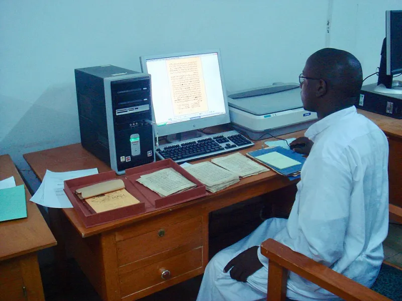
Photo: Carosaun, CC BY-SA 4.0, via Wikimedia Commons
In the popular imagination of Western education, the map is a European invention. Explorers set sail into unknown darkness, and cartographers back home dutifully recorded what those brave men found. The world, according to this mythology, was drawn into legibility by European hands. What this story omits — deliberately, structurally, and consequentially — is that much of the world those European sailors "discovered" had already been documented, named, traversed, and traded across by African peoples for centuries. The maps existed. The knowledge existed. What changed was who got to claim credit for it.
The history of African cartography is not a footnote. It is a suppressed archive, and recovering it demands that we interrogate not only what was erased but why.
The Geographic Intelligence of the Mali Empire
At its height in the 13th and 14th centuries, the Mali Empire governed a territory larger than Western Europe. Administering such a vast domain — stretching from the Atlantic coast of present-day Senegal to the trading centers of Timbuktu and beyond — required a sophisticated understanding of geography. Mali's rulers did not govern blindly. They governed through knowledge.
Trans-Saharan trade was the economic engine of the empire, and trade requires maps — not necessarily in the Western parchment-and-ink sense, but in the form of codified geographic knowledge transmitted through professional networks of merchants, scholars, and navigators. The wangara, the merchant class who moved gold, salt, and kola nuts across thousands of miles of desert and savanna, carried with them detailed mental and material cartographies of water sources, mountain passes, seasonal road conditions, and political territories. This was operational intelligence of the highest order.
Scholars at the University of Sankore in Timbuktu — one of the world's earliest institutions of higher learning — produced manuscripts that included geographic descriptions of territories, trade corridors, and astronomical observations used for navigation. Thousands of these manuscripts survive today in private collections and national archives across West Africa, though many remain untranslated and understudied by Western academia. The geographic knowledge they contain predates and, in many cases, directly informed the European cartographic tradition that would later erase its origins.
Arab-African Collaboration and the Erasure That Followed
Perhaps the most glaring example of African geographic knowledge being absorbed without attribution involves the 12th-century cartographer Muhammad al-Idrisi, whose world map — the Tabula Rogeriana — was produced for the Norman King Roger II of Sicily. Al-Idrisi's work drew extensively on the accounts of African traders, travelers, and scholars who had been documenting the continent's interior for generations. The knowledge of sub-Saharan Africa that appears in his maps did not emerge from European observation. It came from African informants whose names were never recorded.
This pattern — African geographic expertise flowing into European and Arab scholarly traditions while African contributors were rendered anonymous — would repeat itself for centuries. When Portuguese navigators began charting the West African coastline in the 15th century, they did not sail into the unknown. They sailed into waters that African fishermen, traders, and pilots already knew intimately. Portuguese success in navigation along the African coast depended substantially on African guides and local knowledge systems. The maps that resulted, however, bore Portuguese names and Portuguese royal imprimaturs.
East African Seafarers and the Indian Ocean World
On the continent's eastern coast, Swahili maritime communities had been navigating the Indian Ocean for well over a millennium before Vasco da Gama rounded the Cape of Good Hope in 1498. The dhow routes connecting East African port cities like Kilwa, Mombasa, and Malindi to the Arabian Peninsula, the Indian subcontinent, and Southeast Asia were among the most sophisticated maritime corridors in the premodern world.
Swahili navigators used a system of celestial observation, seasonal wind knowledge (the monsoon calendar), and coastal landmark identification that constituted a fully developed navigational science. This knowledge was not written in the form European scholars would later recognize as "cartographic," but it was no less rigorous for that. Oral transmission, material instruments, and embodied practice were the technologies through which this geographic intelligence was preserved and refined across generations.
When da Gama arrived on the East African coast, he was famously guided to India by an Arab-Swahili navigator, almost certainly the pilot Ahmad ibn Mājid, whose own navigational manuals — written in Arabic — drew on centuries of accumulated Indian Ocean knowledge that included substantial East African contributions. European historiography would later transform da Gama's voyage into a story of European genius. The African and Arab navigators who made it possible were reduced to supporting characters, then erased entirely.
The Politics of the Blank Map
The ideological function of the "blank map" — the representation of Africa as an undifferentiated, unnamed, and unknowable interior — cannot be separated from the project of colonialism. European cartographers of the 18th and 19th centuries did not simply fail to document African geographic knowledge. They actively suppressed it. Maps of Africa produced during the height of the colonial era frequently depicted the continent's interior as empty or unknown, even as African communities within those very territories possessed detailed, sophisticated geographic understanding of the land.
As the historian Matthew Edney and others have argued, the blank map was a political instrument. It signaled that Africa was terra nullius — land belonging to no one, claimed by no one, known to no one — and therefore available for European appropriation. The erasure of African cartographic knowledge was not incidental to colonialism. It was constitutive of it. You cannot claim to discover what has already been documented. So the documentation had to disappear.
Reclaiming the Archive
In recent decades, scholars across Africa and the African diaspora have been working to recover and reconstruct these suppressed cartographic traditions. The digitization of Timbuktu manuscripts, ongoing archaeological work at Swahili coastal sites, and the growing field of ethnocartography — which takes seriously the geographic knowledge embedded in oral traditions, material culture, and indigenous place-naming systems — are collectively building a counter-archive to the colonial record.
For American audiences, this history carries particular resonance. The same epistemological violence that erased African mapmakers from the historical record also shaped how the United States was mapped, named, and narrated. Indigenous and African geographic knowledge was systematically excluded from the official cartographic record of North America, while the names and contributions of enslaved Africans who guided explorers through unfamiliar terrain went unrecorded.
Reclaiming African cartographic traditions is therefore not simply an exercise in adding diversity to a fixed historical canon. It is a fundamental challenge to the epistemological foundations of that canon — a demand that we ask not only who drew the maps, but whose knowledge made the drawing possible, and whose erasure made the credit transferable.
The world was never unmapped. It was mapped by people whose names we were never taught. That is the archive we are working to restore.